
Plans. We made them. Had it all figured out. Knew exactly what we’re going to do. But you know what they say about the best laid plans of mice and men.
They often go awry…
But I digress, before talking about plans that go awry, let’s talk about making plans in the first place. This is our second year of RV travel and I’ve managed to develop a system for choosing parks that works. Our style of travel is somewhat different than other RVers. Some people like to stay at big resorts with lots of amenities and activities and others enjoy boondocking for long periods, in the wilderness.
We fall somewhere in the middle.
The most important part of travel, for us, is the ability to go out and explore a 50 mile or more radius while having a comfortable place to come home to. For that reason I look for small, quiet parks, outside the city but with full hookups. I use Good Sam Campgrounds Map and RV Park Reviews to narrow down the choices. Google Maps allows me to zoom in on satellite view for the final determination. The system has worked perfectly and we’ve been happily surprised by the charm of even the most questionable parks. Never would I have imagined that having an extra surplus of parks to choose from would make the job almost impossible.
In order to stick with our “travel the outside of the US” plan, we wanted our next stop to be near Brownsville, Texas. That meant we needed to look at the suburbs outside of Brownsville. I had no idea that “outside of Brownsville” is a HUGE “snowbird” destination. Even so, I wasn’t concerned because we’d be visiting during the off-season. For those of you who are unfamiliar with snowbird destinations, let me enlighten you. Yes, there are literally hundreds of RV Parks to choose from and no they will not all fit your needs and neither will they be financially prudent.
Every single park I looked at was either part of a membership club or they were cities unto themselves, with more activities and amenities than we could use in a lifetime. I began to despair of ever finding a place to stay. Sometimes it’s very difficult to navigate an unfamiliar area via the internet, especially when your destination is not set in stone. A lot of times it’s hit and miss.
I finally found a park in Harlingen Texas called Fig Tree Resort. It sounded like it might work for our needs, so we chose it. What an absolute treasure! From the first time I spoke to them on the phone, to the day we left, I can honestly say that these were some of the nicest, most welcoming people we’ve ever met. They gave us the biggest spot they had (which was a regular spot for a snowbird who had left for the season), happily chattered about all the best places to eat and shop and see, even going so far as to draw directions to the local grocery store because the roads are a little confusing.
The park is a mix of RVs and mobile homes and it is a gated community. They charge a $20 deposit for the gate opener which you get back when you leave. The grounds and rigs and homes are beautifully kept with plants and flowers even though this spot looks a little bare.

Shortly after we arrived, a lovely woman came over to welcome us to the park. She brought us a bag of goodies, tourist brochures, can cozies and lanyards. she apologized that there weren’t as many activities going on during the off season but invited us to the regular happy hour on Thursdays. She explained all about the medical facilities nearby and how the neighbors all looked out for one another and if we needed emergency service they would be right there to help out.
Seriously, THE NICEST PEOPLE EVER!

Anyway…back to plans, or lack thereof.
Our travel motto is “see all the things,” consequently my “exploration” plan-making is a little more intense. During our down-time, I Google Search tourist spots, use Atlas Obscura and Roadside America to find unusual places, look up stuff I’ve read about in books, even go so far as to utilize the zoom option on Google Maps to look for interesting things on the ground…but from space! Isn’t technology great? When I find something I like, I bookmark it into my Google Chrome folders which I have organized by state.
A little obsessive perhaps, but it works.
Even so, sometimes, it’s the drive itself rather than the destination.

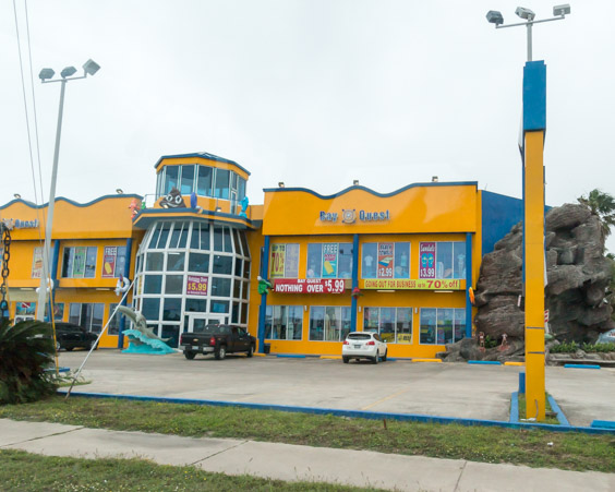
Look at this old gas station!!!!!
Brownsville has it’s own folder with a list of places to see. Number one on that list, a boat ride through the Port of Brownsville. It’s here that oil rigs are repaired, old aircraft carriers are torn apart and other wonderfully, fascinating things are built and shipped and moved around. Jeff and I may be a bit odd but we’re interested in everything, how things work, how things are made, where things come from, why did they end up like that? We spend a lot of time pondering, therefore we were very excited about this boat ride. The boat leaves from a dock in Port Isabel and while I found some information about the tour, the information itself was lacking, it didn’t seem complete. We planned to stop in at the boat dock to buy tickets for the afternoon, but first we wanted to explore Port Isabel.
While driving down the main road into the town it quickly became apparent that they have a very distinctive style of building decor!


I’m sensing a theme.

This is a laser tag/ small amusement park.
Cruising around the edges of Port Isabel we found…

A lift bridge into a private community…

A beautiful raised cemetery tucked in between condos and expensive homes…

The incredibly designed, supposedly haunted, 1926 Yacht Club Hotel…
Port Isabel’s main claim to fame is it’s lighthouse which was built in 1852. During the Civil War it was occupied by soldiers from both sides as a look-out post. Before that, the land was the site of Fort Polk. The fort was erected by Zachary Taylor and used as a depot to receive supplies from New Orleans.
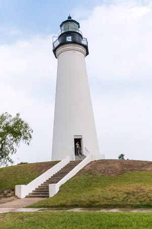
Climbing 120 steps to the top offers a bird’s eye view of the bay.
Once our explorations were complete, we moseyed on over to the boat dock to inquire about the port tour, only to be informed that the tours had been cancelled due to increased concerns of terrorism. I guess that explains why the information on the internet was incomplete.

Looking wistfully over the bay toward South Padre Island from the boat dock.
Our plans have most definitely gone awry. There’s nothing for it but to drive across the bridge and explore South Padre Island.

I can honestly say that I’ve never seen a “watch for pelicans” bridge sign. What do they do? Dive bomb cars?

South Padre in the distance, I’m consoling myself about the boat tour by thinking that since it’s foggy we probably couldn’t have seen much anyway.
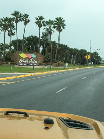
Made it! It’s too early to eat, way to early to drink, it’s not spring break and it’s foggy and the ocean is cold. Since we’re explorers we opt to drive to the very end of the road just to say we did.
Past the condos, hotels and restaurants…the dunes take over.

How often do they have to clear the sand?


The end was anticlimactic.
The good news is, a little way back, at beach access #5 or #6 you can pay $12.00 to drive on the sand. A $10.00 fee plus $2.00 trash bag fee. If you bring the bag back, preferably with trash you picked up, the $2.00 is refunded.

First view of the ocean! Goodbye desert!
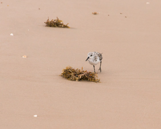
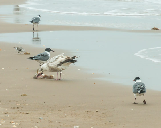
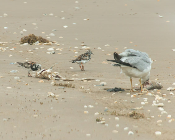
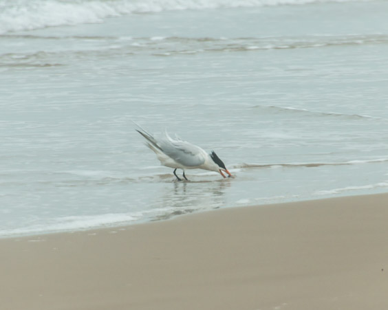
The Rio Grande Valley and environs are critical areas for migrating birds, over 500 species have been sighted in the valley around Harlingen (where we’re staying). The World Birding Center is also located in Harlingen and there are nine, bird viewing centers all along the river valley. South Padre Island itself is an important part of that network and many different birds, some familiar, some not were hanging out on the beach.


Royal Terns always look as though they’re about serious business.

Fisherman, cars and horses share the beach near the access road.

The Gulf of Mexico so pretty!

The distance you can drive on the beach from the access road to the north jetty is about 26 miles. The beach surface varies from hard sand to small dues and in some spots the road goes through water. You must have high clearance, 4 wheel drive. Most people cluster around the access points and as we drive further and further we often have the beach to ourselves. Between the thin fog and the dunes it looks like the road ends, yet we’re able to drive mile after mile.

I guess they smooth the beach out too?

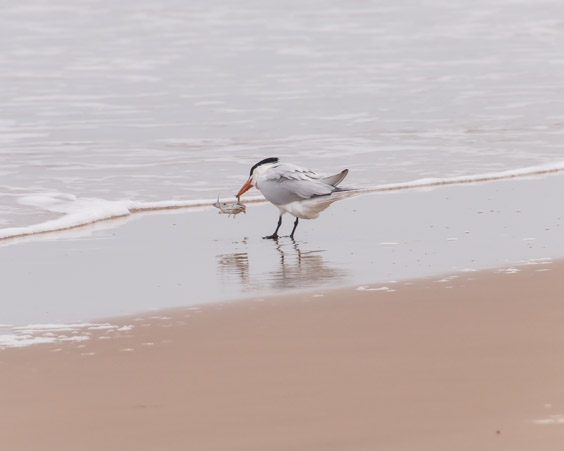
Fish washed up or left behind make birds both large and small very happy!
The further down the beach we get, the wilder and narrower it gets. The ocean itself seems restless, the breaks are bigger, the fog is thicker and we are alone.


Getting past requires driving in the water.
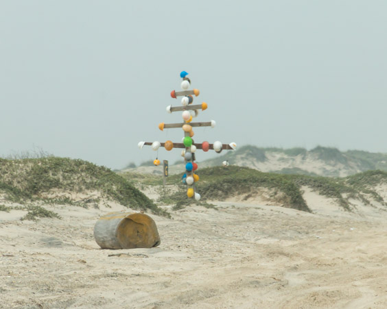
This is different territory for us and every bit of it is interesting. Part of it is sad, trash and plastics have been washed up and the black on the beach is oil from the many pipelines that run through the Gulf, but to us and apparently others, it’s like treasure hunting. We imagine that the fisherman or local beach goers create these trash totems to mark a favorite spot.

Hard hats washed off oil rigs perhaps?

This one fell but someone took some time, the plastic caps have been nailed on.

I wonder how far this buoy has traveled to wind up stuck on a sandbar?

A dead ray?


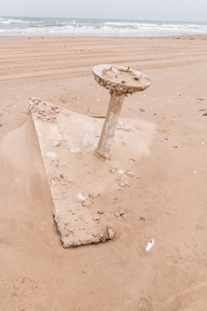
I’ll bet this huge tank has a story to tell.

Quite a few (dead), Portuguese Man-of War. They’re incredibly beautiful but deliver a painful sting which can be deadly to children.
They can sting when dead so don’t touch!
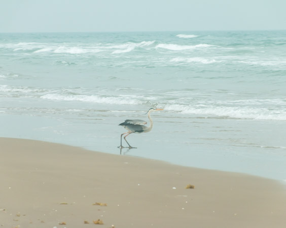
Blue cranes congregate near fisherman but don’t appreciate cars.

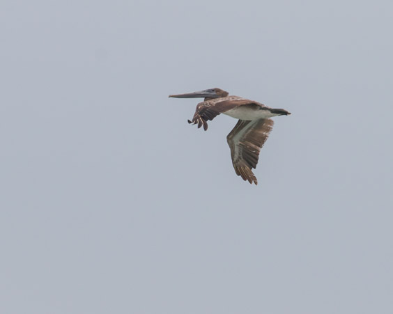
These four pelicans flanked us and guided us for miles.

Of all the birds I tried to photograph, the pelicans were the hardest to catch.


This is the end of the road for us. We could make it across if we wanted to but several trucks were at the jetty fishing. We didn’t want to disturb them.


Thanks to a zoom lens this is the end of the jetty which marks a cut through the barrier islands of Padre and South Padre.
Time to turn around and search for more treasures as we stop along the way.
The whole beach is full of shells.

Most are broken, they must have weathered many storms and hard knocks before landing here.

Even broken, they’re still beautiful. Kind of a metaphor for life…
Sometimes treasures are big…


Like this imbedded shipwreck.

Or this gigantic tree in a place where there are no gigantic trees.
Sometimes treasures are small…

Ironic baby, bath “sealife” toy.

Plastic cap or life raft? You be the judge.

Ship light?

Some bird lost a toupee.

How amazing is this? This branch was very long and absolutely covered in shells. How long did it float around before it was covered and landed here?
Even the most ordinary things can become a haven for sea life.
Ordinary table from a boat?

Or someone’s home for a time?

I have NO idea what conglomeration this is but it’s attached to a zip tie and contained some life forms. Where there’s a will there’s a way!

Sometimes a treasure means being in the right place at the right time.
This bird was having a very hard time with his dinner!
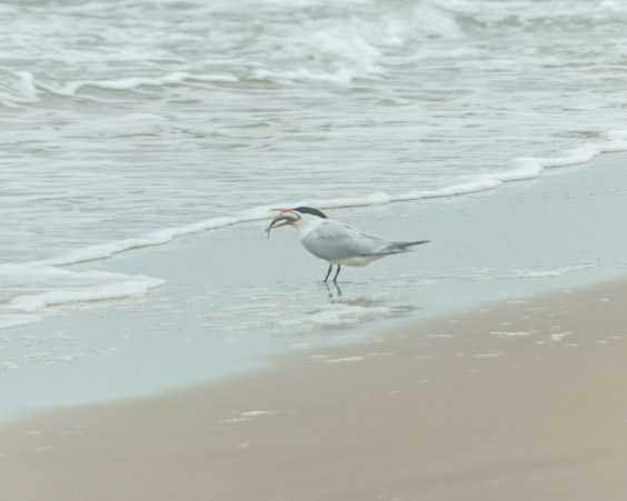
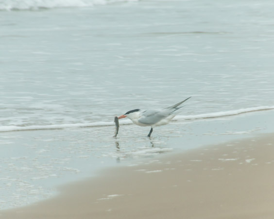
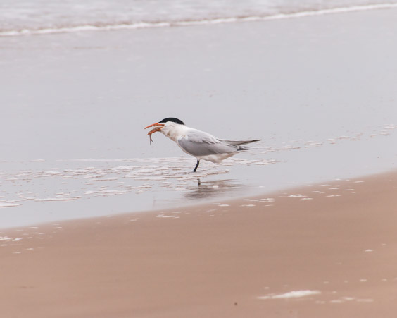
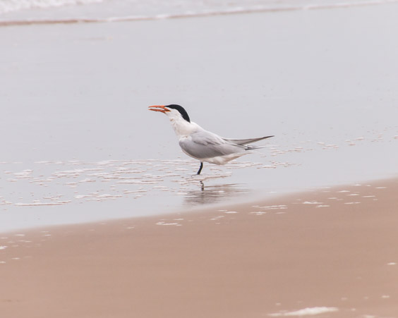
Success! Swallowed it whole!
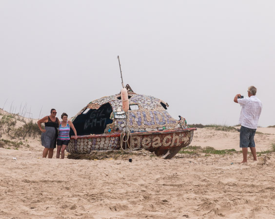
Somehow we missed this giant treasure the first time. These people were having a full photo shoot that was taking forever! The buoy, or whatever it is, says nude beach with an arrow. It’s covered and decorated with shells and smashed beer cans. Since there’s no nude beach here it must have traveled a ways.
Quite a work of art but we couldn’t wait around forever to get closer…sigh.
Sadly it’s time to leave our beach adventure for paved roads.

We are starving by the time we get to town and decide to try a place called Burgerfi.
Burgerfi is a gourmet burger place which serves burgers, fries, shakes, craft sodas and beers. The burgers were thick, juicy and delicious and the onion rings were some of the biggest I’ve ever had.
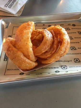
Highly recommend it!
Once again, it’s not dark yet, time to explore the south end of the island so we can say we did the whole thing. The south end sits on the channel which enters the Port of Brownsville. Boat tours and dolphin sighting tours are permitted here but not up into the port itself.

Even pirate ships are allowed, go figure!
The most prominent sight in the park is this mini Christ The Redeemer statue, a copy of the one in Brazil. This statue is a monument to fishermen lost at sea.

The best way I can think of to end this post is by showing the unadulterated joy of this man and his birds.


The best treasure of the day!

Karen…one correction…not the Atlantic Ocean, the Gulf of Mexico…love your blog!
LikeLiked by 1 person
Ha ha thanks we travel so much I forget where I am half the time.
LikeLike