
The saga continues…
Despite the fact that we drove for 11 hours yesterday, we are STILL having trouble sitting still…
…and feel the need to drive several miles around Mt Lassen National Park today. Our new neighbor sits calmly in his chair (he’s been in that same position since last Friday) laughing quietly under his breath…
I say “Teach us your ways” He smiles slightly and slowly replies with a drawl, “Well, first you take a sharp knife and poke at your tires, then you let all the air out.”
Solid advice!
Before I continue, I’d like to share 3 more things I’ve learned about RV travel.
- RV refrigerators are fickle things.
- So are “on demand” water heaters.
- and why is the $%^#$@ water pump constantly running?
We’ve learned that this ‘aint your home fridge kid! After much research we run the generator while driving, turn the fridge up to the coldest setting the night before a drive and add blue ice to the box. Not sure if it’s right but it works…
The water heater is like riding a wave, first the fires of Mt Doom, which then becomes glacial runoff, then back to Mt Doom.
I’ve learned to adapt…
Ah….the water pump…seems it wouldn’t turn off whether the switches were off or not. Every time we plugged into power the @#$%#@ thing would come on and sputter quietly away under the bed…ALL NIGHT LONG.
After the second night of this nonsense, Jeff was so fed up he pulled the fuse. Quiet. The next morning we searched again and AHA! There is a THIRD switch in the main control panel. It seems we’re just a little too short and blind to read the print on the switch and mistook it for a main power switch. Problem solved!
So we begin our day at the Shingletown KOA which is a very nice, quiet park, nestled in the pines. It felt like my home town of Crestline, California. I LOVED it there. The park was mostly empty and the owners and staff were wonderful.
After saying goodbye to the “still sitting” neighbor we drove off to the Lassen National Park entrance via highway 44.
We have a lifetime senior pass for the National Park System which I highly recommend. Getting in free saves a lot of money in entrance fees.
Our first stop was the Loomis Museum and visitor center where we saw a very interesting movie about the parks history including film of the 1915 eruption. It’s surreal realizing how recent the eruption was and how lush and green it looks now. The historic museum was built in 1927 by BF Loomis. His original home also sits on the land and now houses the Park Administration. The museum has a wonderful collection of the photos Loomis took of the eruption.

After the museum we continued on to the Chaos Jumbles area where 340 years ago, one of the domes collapsed and a rock avalanche occurred. It was so powerful, it rode on a cushion of air and rushed down the mountain at over 100 miles an hour obliterating everything in it’s path.

As we continued down the road we came to the most beautiful meadow I’ve ever seen!


Pictures do not do it justice. The colors were so vibrant and gorgeous. I wanted to settle down and build a house right there! It’s an easy walk across the street from a parking lot but there were signs which said “Paradise meadow trail 1.5 miles”. I’m not sure if this was Paradise meadow or if there was an even better meadow further in but since we didn’t know how long our round trip would take us, we continued on without investigating.
The views were glorious near the top of the peak.

The parking lot at the trailhead for the summit of Mt Lassen Peak sits at 8500 feet and the trail continues straight up.
We said NOPE!


Right down the road is beautiful little Lake Helen.

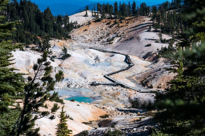
…and right around the corner from that is the parking area for the trail to Bumpass Hell, still at 8500 feet. Now this was news to me as this was the hike I had researched (apparently not well enough) and wanted to take. It is 3 miles round trip, ascends gently 500 feet with a descent of 250 feet at the end. Sounds easy enough.
Things aren’t always what they seem…onward and upward!


This is the gentle ascent part.
Beautiful views…

Finally a view into Bumpass Hell.
The roaring of the steam is really loud from here.
The hike down is very steep and the smell of sulfur is strong.
At the bottom are bubbling mud pots, roaring stem vents, and springs that look like cement.
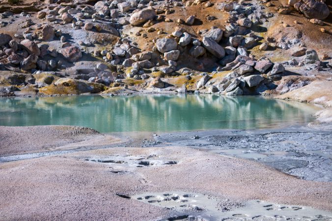

Lot’s of signs…Stay on the boardwalk! Sounds like a good idea to me!

We walked around a bit then started back up the trail. As I was taking my time walking back UP the VERY steep trail and trying to remember how to breathe, I was treated by the sight of a mom and baby in the meadow below.

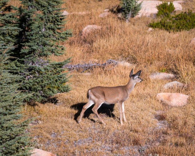
Going slow does have its perks.
People who were on the way down, asked us how bad the sulfur smell was at the bottom. They were concerned because they had asthma. I have asthma and the smell didn’t bother me because it was constantly being blown away by the breeze. The part that DID bother me, was the thin cold air, elevation and climb back up. I had to take it in short bursts, walk a little way until my lungs were burning and my heart was pounding, rest for a minute and do it again.
At last, the sight I longed to see! Ampy, our jeep in the parking lot! This is zoomed, still a long walk…

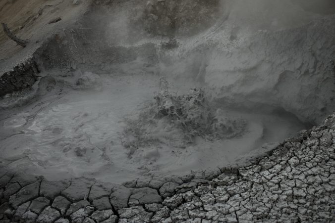
It was about 4:30 when we got back to the parking lot and the sun was starting to go down behind the peaks. We opted to continue the park loop drive and a few miles down the road we came to The Sulphur Works.
The Sulphur Works is another surface area with hydrothermal activity and there is a HUGE bubbling mud pot right next to the road. Apparently the level of the mud pot activity varies at different times. When we were there, the park had erected a plywood barrier because the pot was bubbling so much it was splashing the sidewalk.
It was getting dark so I couldn’t get a very good picture.
I could have watched it all day, it was mesmerizing.
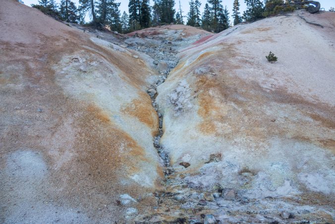
This embankment is by the road, also part of the Sulphur works.
In making the loop around the park we ended up on highway 89 and from there we were going to take highway 36 to get back to camp. The GPS informed us that the quickest way from highway 36 back to Shingletown was via county road A6. I remembered that the driving directions to the KOA stated very emphatically DO NOT take County road A6 with your RV, take highway 44.
Now I know why….County road A6 was a spectacular road winding through tiny towns and volcanic canyons, with rustic cabins and deer grazing in front yards. We drove it as the sun was setting and the colors were warm and gold and red. I wish I could have taken pictures but it was too dark.
I could live on this road, it’s SO pretty but you DO NOT WANT TO DRIVE AN RV ON IT!
Very steep and winding.
I wanted to go back and explore it further but as usual, after resting tomorrow it will be time to move on…sigh.

Gorgeous photos!
LikeLike